University of Wisconsin - Eau Claire
B.S. Biology
B.S. Geography
Geospatial Certificate: Remote Sensing Emphasis
B.S. Geography
Geospatial Certificate: Remote Sensing Emphasis
Geospatial Analysis of the Role of Agricultural Practices on Hypoxic Zone Development in the Mississippi River Delta: A Multitemporal Perspective
Advisor: Dr. Cyril Wilson
Funded by the University of Wisconsin - Eau Claire Faculty/Student Research Collaboration Grants Program
Conferences Presented At:
Spring 2016
Evaluating dead zones, also known as hypoxic zones or regions of water lacking adequate oxygen content, is of extreme importance when monitoring the health of marine ecosystems. Determining the spatiotemporal configuration and quantifying the causes of these oxygen deficient waters is crucial. By enumerating the spatial extent of dead zones and assessing the land-based causes for these regions of hypoxia, it is possible to define more efficient mitigation measures. Using remote sensing and spatial statistical techniques, this study explores the relationships between land use in the Mississippi River watershed and dead zone development in the Mississippi River delta at three times-steps– 2001, 2006 and 2011. Results of the study demonstrated statistically significant positive relationships between agricultural land use practices and hypoxic zone creation. To better understand more specifically the role which nitrogen fertilizer runoff from the Mississippi River watershed plays data hypoxic zones were quantified in September of 2001 and 2006. The outcome of this study is invaluable since it aids in pinpointing the major land-based causes of hypoxic zone development and will aid in assisting environmental planners in developing adequate mitigation measures for dead zone remediation.
Funded by the University of Wisconsin - Eau Claire Faculty/Student Research Collaboration Grants Program
Conferences Presented At:
- American Association of Geographers Annual Meeting - 2016 (San Francisco, CA)
- ASPRS Annual Meeting - 2016 (For Worth, TX)
- CERCA Student Research Fair - 2016 (Eau Claire, WI)
Spring 2016
Evaluating dead zones, also known as hypoxic zones or regions of water lacking adequate oxygen content, is of extreme importance when monitoring the health of marine ecosystems. Determining the spatiotemporal configuration and quantifying the causes of these oxygen deficient waters is crucial. By enumerating the spatial extent of dead zones and assessing the land-based causes for these regions of hypoxia, it is possible to define more efficient mitigation measures. Using remote sensing and spatial statistical techniques, this study explores the relationships between land use in the Mississippi River watershed and dead zone development in the Mississippi River delta at three times-steps– 2001, 2006 and 2011. Results of the study demonstrated statistically significant positive relationships between agricultural land use practices and hypoxic zone creation. To better understand more specifically the role which nitrogen fertilizer runoff from the Mississippi River watershed plays data hypoxic zones were quantified in September of 2001 and 2006. The outcome of this study is invaluable since it aids in pinpointing the major land-based causes of hypoxic zone development and will aid in assisting environmental planners in developing adequate mitigation measures for dead zone remediation.
Spatially Varying Relationships Between Agricultural Land Use and Hypoxic Zone Development in the Mississippi River Delta
Advisor: Dr. Cyril Wilson
Awarded 3rd Place in the Undergraduate Research Competition: West Lakes Regional Division of the AAG
Conferences Presented At:
Fall 2015 - Fall 2016
Hypoxic zones, otherwise known as dead zones or regions of water lacking adequate oxygen content is a conspicuous problem in coastal areas with significant ecological and economic implications. Quantifying the spatial extent of dead zones is pivotal but a more promising exercise is to determine and assess the land-based causes of dead zones because adequate mitigation measures can be easily and more efficiently applied to the causes rather than cleaning up hypoxic zones in coastal marine ecosystem. Using remote sensing and spatial statistical techniques, this study is designed to better understand the relationships between land use in the Mississippi River watershed and dead zone development in the Mississippi River delta at three time-steps– 2001, 2006 and 2011. Results of this study will be invaluable to land use, watershed, and environmental planners in developing adequate mitigation measures for dead zone remediation.
Presentation from the West Lakes Regional Division of Association of American Geographers below:
Awarded 3rd Place in the Undergraduate Research Competition: West Lakes Regional Division of the AAG
Conferences Presented At:
- West Lakes Regional Division of Association of American Geographers - 2015 (Eau Claire, WI)
- ASPRS Spotlight Event - 2015 (Eau Claire, WI)
- CERCA Student Research Conference - 2015 (Eau Claire, WI)
Fall 2015 - Fall 2016
Hypoxic zones, otherwise known as dead zones or regions of water lacking adequate oxygen content is a conspicuous problem in coastal areas with significant ecological and economic implications. Quantifying the spatial extent of dead zones is pivotal but a more promising exercise is to determine and assess the land-based causes of dead zones because adequate mitigation measures can be easily and more efficiently applied to the causes rather than cleaning up hypoxic zones in coastal marine ecosystem. Using remote sensing and spatial statistical techniques, this study is designed to better understand the relationships between land use in the Mississippi River watershed and dead zone development in the Mississippi River delta at three time-steps– 2001, 2006 and 2011. Results of this study will be invaluable to land use, watershed, and environmental planners in developing adequate mitigation measures for dead zone remediation.
Presentation from the West Lakes Regional Division of Association of American Geographers below:
Biodiversity Study in the Monk's Community Forest, Cambodia
Advisor: Deborah Freund
Fellow Investigators: Morgan A. Euteneuer, Alexandra G. Hillstrom, Jonathan E. Schenk, and Peter Tha
Conferences Presented At:
Winter 2014 - Spring 2015
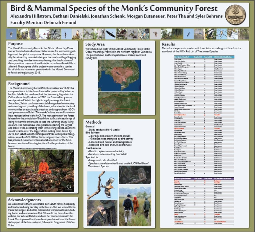
The Monk’s Community Forest in the Oddar Meanchey Province of Cambodia is a fundamental resource for surrounding villages and the global ecosystem. However, the forest is continually threatened by unsustainable practices such as illegal logging and poaching. In order to convey the negative implications of these practices, conservation efforts focus on how the wildlife are affected. The purpose of this project was to compile a species list of birds and mammals present within the Monk’s Community Forest during January, 2015. Over a period of three weeks, image and audio data were collected daily. Typically, bird surveys were conducted twice per day; once in the early morning and again in the late afternoon. Additionally, trail cameras were used to record wildlife activity at various locations throughout the forest. The photographs and audio recordings were analyzed to identify species and combined with previous survey data to generate the species list. Our motivation for the project was to raise awareness of the ecological importance of the forest and promote its conservation. We anticipate our findings will encourage the funding of protection efforts for the Monk’s Community Forest.
Poster presented at the CERCA Student Research Conference below:
Fellow Investigators: Morgan A. Euteneuer, Alexandra G. Hillstrom, Jonathan E. Schenk, and Peter Tha
Conferences Presented At:
- CERCA Student Research Conference - 2015 (Eau Claire, WI)
Winter 2014 - Spring 2015
The Monk’s Community Forest in the Oddar Meanchey Province of Cambodia is a fundamental resource for surrounding villages and the global ecosystem. However, the forest is continually threatened by unsustainable practices such as illegal logging and poaching. In order to convey the negative implications of these practices, conservation efforts focus on how the wildlife are affected. The purpose of this project was to compile a species list of birds and mammals present within the Monk’s Community Forest during January, 2015. Over a period of three weeks, image and audio data were collected daily. Typically, bird surveys were conducted twice per day; once in the early morning and again in the late afternoon. Additionally, trail cameras were used to record wildlife activity at various locations throughout the forest. The photographs and audio recordings were analyzed to identify species and combined with previous survey data to generate the species list. Our motivation for the project was to raise awareness of the ecological importance of the forest and promote its conservation. We anticipate our findings will encourage the funding of protection efforts for the Monk’s Community Forest.
Poster presented at the CERCA Student Research Conference below: